The scenario the USGS developed in 2010, with help from more than 100 experts and agencies, modeled what modern California might experience from a weather event of the magnitude that caused the state’s Great Flood of 1862. This “megaflood,” unique in recent history of the West, destroyed a third of the property in the Golden State. Large regions remained “inland seas” for months; the entirety of the capital, Sacramento, was under 10 feet of water. The event took thousands of lives and forced the state into bankruptcy.

Recently, UCLA climate scientist Daniel Swain revisited the ARkStorm scenario taking the influence of a warming atmosphere into account. His analysis of the “plausible worst case scenario” for a future megaflood revealed that climate change had already doubled the risk of catastrophic floods in California, a risk that will continue to increase as warming continues in coming decades.
“Even if there were no climate change, this would be a risk, it's just that climate change is dramatically upping the odds,” says Swain. “And that is important.”
The exact mechanisms behind storm formation vary from region to region, but the interplay between warmer air, rainfall and flooding has been playing out in real time this summer in many parts of the country. California may face a particular kind of risk, but it’s not the only state facing new challenges.

(NOAA)
Imagining an ARkStorm
The phenomenon fueling the massive precipitation behind past and future megafloods in California is known as an “atmospheric river.” These long, narrow columns of water vapor can transport water at a rate as much as 15 times the daily discharge from the Mississippi river. They are the largest fresh water “rivers” on earth, an average 250-375 miles wide.
Atmospheric river formation begins near the equator, where direct sunlight causes water to evaporate. The vapor can be pulled toward coasts by atmospheric circulation. When it reaches land and is pushed upward, the vapor condenses and falls as rain or snow.
Atmospheric rivers have caused recent severe storm events in California and are considered to be the likely cause of the 1862 floods. For this reason, the USGS named its scenario “ARkStorm” — “AR” for the river in the sky and “k” denoting a thousand-year event, with a nod to Noah’s travails. (The Great Flood of 1862 followed 30 consecutive days of rain; this was used as the basis for the original USGS modeling and Swain’s recent research.)
The ARkStorm scenario published in 2010 prompted meetings, conferences, research, policy discussions, work groups and other activities that continue to this day. A group including USGS, the National Center for Atmospheric Research, the California Department of Water Resources and UCLA’s Institute of the Environment and Sustainability, where Swain works, is presently working on ARkStorm 2.0.
Swain’s latest research is an integral part of this effort, which is less a rethinking of the original scenario than a refining of it using current climate science and modeling tools. “We’re going to calculate it even better than we did the first time around,” says Anne Wein, a USGS disaster scientist who was among the co-authors of the first report. “We’ll retell the story with a climate change accent, and it will help everyone with their planning for all kinds of flooding.”
Part of this work will involve updating estimates of the impact of an ARkFlood on the state’s economy and infrastructure. Translating updated flood modeling into economic impact estimates will require input and expertise from hundreds of people and take years to complete, Wein says.
Other parts of the country may have less to fear from atmospheric rivers, but warming is changing rain patterns in ways that are increasing flood risk throughout the country.
More Drought and More Rain
In a seeming paradox, drought and flooding are two sides of one coin, says Swain. A warmer atmosphere can hold more water, and higher temperatures cause more water on the Earth’s surface to evaporate. This can result in bigger rainstorms.
It’s ironic that Swain’s research warning of flood risk was published during the West’s worst drought in 1,200 years, but it would be a mistake for the public to think the current historic drought offsets the risk of a historic flood. “We ignore that risk at our peril.”
Warmer temperatures and increased atmospheric concentrations of water, if not atmospheric rivers, are also factors in floods that have plagued other parts of the country this summer.
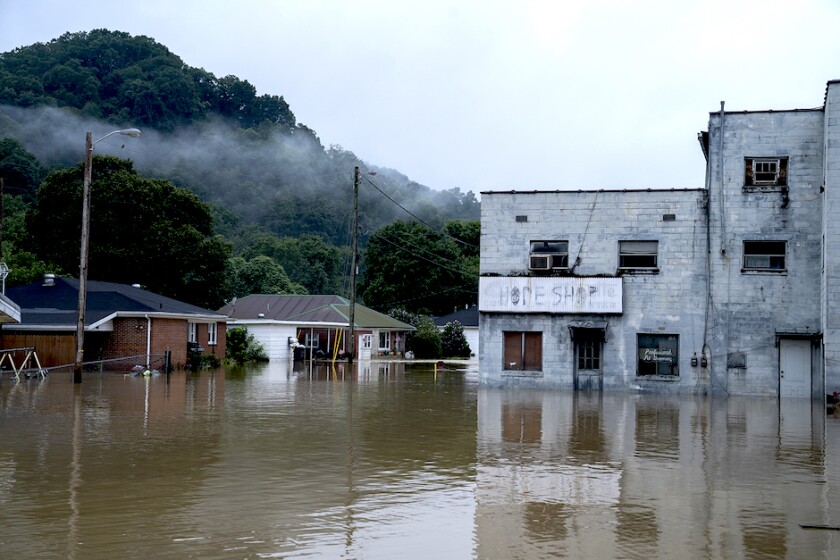
“In the past two months, we have seen five different thousand-year rain events scattered across all parts of the country,” says Victor Murphy, climate service program manager for the National Weather Service’s Southern Region. “That’s being brought about by global warming, hook, line and sinker.”
The Jackson, Miss., flood that pushed a monthlong safe water crisis over the edge into a public health emergency was a hundred-year event, a 1 percent likelihood, according to historical trends. But rain patterns are diverging from past norms throughout the country, says Murphy.
Total rain per year is not likely to change, but longer dry periods will be followed by shorter, more intense bursts of rain. Texas is a “poster child” for this shift, says Murphy, who lives in Fort Worth.
“We went 67 days without measurable rainfall, the second-longest streak going back to 1898. Then all of a sudden, parts of Dallas got 15 inches in 12 hours’ time.”

(Juan Figueroa/TNS)
Changing Assumptions
Extreme weather events resulting from either the lack or the abundance of precipitation are requiring more time and thought from those responsible for emergency management, says Erica Bornemann, director of Vermont Emergency Management and the president of the National Emergency Management Association (NEMA).
“There's not a meeting or a conference that I go to with any of my colleagues where we don't reference the increased severity, frequency and complexity of these events,” says Bornemann.
Assumptions that have historically been used to plan for weather emergencies don’t apply as they become more severe and more frequent, she says. That means more resources are needed for planning and for executing plans.
Urban areas may have full-time emergency management staff, but many rural communities have an appointed “director” who volunteers in their spare time. “That’s not good enough,” says Bornemann. Emergency management and disaster preparedness should be considered core function of every local government and every state government.
Vermont’s annual rainfall is well above the national average, but it’s beginning to experience longer periods of drought and small wildfires. For now, these problems are nowhere near the scale seen in Western states, but Bornemann is concerned about the changes that coming decades might bring.
Climate is changing the way that natural hazards impact states, and emergency managers are depending on the continuing evolution of climate science and data from studies such as Swain’s to inform their planning.
Bornemann is glad to see increasing attention to hazard mitigation, a topic she found to be an “afterthought” when she began her work in emergency management 16 years ago. Recent legislation has made billions of dollars available for climate adaptation and infrastructure improvements, but these projects take time.
“We can’t let off the gas pedal; we’re losing the race because these weather events are happening now, and they are only going to get worse.”
(Michael Swensen/TNS)
A Lot of Flooding
ARkStorm was conceived with a sense of urgency, aiming to provide science that could guide policy. This came with a recognition of the gap between existing policies and infrastructure and what would be required to withstand catastrophic flooding.
“People are going to have to realize that there is no way to fully contain the volume of water that we’re talking about,” says Daniel Swain. “There is going to be a lot of flooding — the question is where does that flooding occur?”
Data from new modeling incorporating Swain’s recent research can help answer this question. This includes accounting for factors such as increased runoff from the Sierra Nevada due to decreased snow levels or in areas impacted by high-intensity wildfires.
Nature-based solutions are likely to play a big role in preventive efforts. “After a certain point, it does not make sense to build ever higher flood walls and higher dams and higher levees,” says Swain. “If you build a really high flood wall and it fails, that’s worse than not having the flood wall in the first place.”
Such strategies include river bypass channels, expanding floodplains and restoring forests and meadows. Megastorm scenarios have created opportunities for local government to reconsider stormwater management, says Reid Bogert, senior stormwater program specialist for the San Mateo Countywide Water Pollution Prevention Program. Stormwater has been traditionally viewed as a nuisance, a kind of waste.
Following on a climate modeling process, the county’s plans for stormwater management incorporate green infrastructure systems than can absorb or even filter stormwater. Street and block-level projects will be designed to incorporate curb extensions that act as “rain gardens,” capturing flow off the street, sidewalk and adjacent properties. Parcel-scale development will incorporate features that reduce impact on the absorptive capacity of the soil beneath them. A Green Infrastructure Design Guide supports this work.
Moving people, businesses and infrastructure out of flood-prone areas might be viewed as another accommodation to nature, but resistance is great. Mentions of “managed retreat” have led to the shutdown of conversations, especially as elements of city plans, says Patrick Barnard, a research geologist at the USGS Pacific Coastal and Marine Science Center.
“Even if they have some confidence in the science, asking someone to leave their home goes beyond logic and reason and gets into an emotional conundrum,” he says.
“Scientists are not going to tell people what to do, and it’s a very difficult situation for state and local governments to identify areas that may not be livable decades from now and get people out of harm’s way in a fair and equitable way.”
Barnard, a co-author of the 2010 USGS report, hopes to at least see progress in regard to restricting new development in areas subject to sea level rise. Rising sea levels raise water tables and saturate soil, increasing vulnerability to earthquakes, reducing capacity for soil to absorb runoff, affecting building stability and pushing saltwater into drinking wells.

(Ken James/California Department of Water Resources)
Cataclysm on a Tabletop
In the initial ARkStorm work it became apparent that one of the big difficulties in responding to a large-scale atmospheric river storm is determining when it moves from manageable to unmanageable, says Michael Anderson, state climatologist for the California Department of Water Resources (DWR). Such forecasts guide decisions regarding such things as evacuation or sheltering in place, and coordination between state and federal agencies.
Ten years later after USGS issued its megaflood report, DWR has access to computing power and resources that enable it to create simulated storm events, both under current conditions and as warming continues to unfold in coming decades. This makes it possible for an updated ARkStorm scenario to encompass storm facets such as wind, precipitation and temperature.
“What we’re hoping to do is take this storm scenario and work with other partners to take it from a storm scenario to a flood scenario,” Anderson says.
This will form the basis of tabletop exercises in which the members of the emergency response community work through various situations and consider the choices they might make as the storm develops and their consequences, as well as alternative responses.
Anderson intends for this work to translate into innovation across the state. “The idea is to make you contemplate these questions before you are facing a real-life situation; it’s a positive, collaborative effort.”
It’s possible these exercises could increase understanding of how infrastructure and climate adaptation projects funded with IIJA dollars could be tweaked or prioritized in service of flood risk mitigation.
“Warming is definitely changing the nature of our extreme events,” Anderson says. “The trickiest part about how we move forward is that we don’t have the historical context anymore for what might happen.”

(Norm Hughes/California Department of Water Resources)
Not Hypothetical
The storm envisioned by the ARkStorm project is hypothetical only in the sense that it hasn’t happened yet. The scenario is grounded in actual events, illuminated by accepted climate science.
Rainfall has caused floods on this scale in California every 100 to 200 years, according to geologic evidence. A 2017 atmospheric river storm that ended a six-year drought brought as much water as the USGS had modeled for the ARkStorm, says Weis. “But it fell over 80 days. We were lucky because it was spread out.”
In the next 40 or 50 years, Swain expects to see a decade where things shift. Not a permanent shift, but an especially wet decade that brings a cluster of events in El Niño years, when megafloods are more likely. “That’s when the risk of flooding is going to be high.”
Swain compares current perceptions of megaflood dangers to attitudes about “megafires” 15 or 20 years ago. Scientists had long predicted that climate and other factors were going to make wildfires a much bigger problem.
“But it hadn’t happened dramatically — we weren’t seeing million-acre fires. I don’t think anyone would have imagined that there would be 10,000 structures burned in a day in a single fire, but now we’ve seen that happen.”
On the other hand, a megaflood hasn’t happened in the living memory of Californians, enabling incredulity that an event of such magnitude could really happen.
Members of the general public are focused on their daily lives, Bornemann says, and contemplating climate catastrophes is a big ask. It’s easy to take the attitude that there’s nothing one person can do, but she sees data of the kind contained in Swain’s report as empowering.
“You can take small steps to be prepared. I was talking to a woman in a flood-prone, low-income area of New Orleans, and her family’s ritual is to put a thousand dollars aside from their tax return in case they get impacted by a hurricane that year.”
Swain hopes the work he and his colleagues are doing might prevent future claims that vast harms inflicted by a megaflood were unforeseeable. The goal is to use science to compel policymakers to do something, “preemptively rather than reactively.”
Related Articles