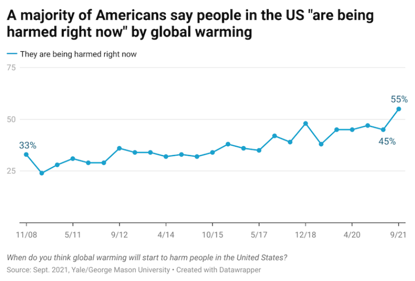
In hope of averting the worst impacts of warming, the 2015 Paris Agreement set a goal of keeping the global temperature rise to 1.5 C above pre-industrial levels. But in a September 2021 report, the World Meteorological Organization warned that steadily increasing atmospheric concentrations of greenhouse gases could cause this threshold to be passed within five years. United Nations Secretary-General Antonio Guterres described the report as “an alarming appraisal of just how far off course we are.”
However, an assessment from the United Nations Environment Programme (UNEP) published earlier in the year had outlined a possible way forward in the face of an accelerating crisis. Reducing human-caused methane emissions by 45 percent over the next decade, it said, could prevent nearly 0.3 C of global warming by the 2040s and keep warming below 1.5 C.
“We have the technology that we need to stop a lot of the methane that’s currently being released into the atmosphere,” says de Belloy. “The problem is more often the fact that we don’t know where leaks or releases are happening.”
High Tide is providing principal funding for a groundbreaking public-private partnership to develop a satellite-based data stream that will transform the ability of state and local agencies to spot and fix methane problems.
Why Methane Matters
Methane, says UNEP, is responsible for about 30 percent of the warming that has occurred since pre-industrial times. A recent analysis by the National Oceanic and Atmospheric Administration (NOAA) found that despite the economic downturn in 2020, atmospheric methane increased at the highest annual rate since regular measurements began in 1983.
Human activities account for more than half of methane emissions, from fossil fuel use, landfills and agriculture. (Cow belching turns out to be a bigger source than cow flatulence.) According to the EPA, landfills and natural gas and petroleum systems account for almost half of emissions from human activity in the U.S.
Methane can also come from the decomposition of organic materials in wetlands, bogs or marshes. It can be released from the ocean, in part as the result of the digestive processes of plankton and fish, or from melting ice crystals. Microbes in the guts of termites produce 11 percent of emissions from natural sources.
Warmer temperatures caused by human activity can create a negative feedback loop and cause more emissions from natural sources, as more ice and permafrost thaws. This phenomenon may be a significant factor in the methane increases seen in recent years, making it even more urgent to slow warming by reducing human emissions. Beyond this, methane contributes to the formation of ozone, a short-lived greenhouse gas that, on a global level, is responsible for hundreds of thousands of deaths each year.
“Methane has about 90 times as much warming potential as an equivalent amount of CO2 released in the atmosphere,” says Riley Duren, a research scientist at the University of Arizona. “So there’s this idea that if you can quickly find and repair methane super emitters, you can have an immediate climate benefit.”
Duren served as a chief engineer at the NASA Jet Propulsion Laboratory (JPL) for more than a decade, working on space-borne instruments and airborne studies. He maintains a position at JPL as an engineering fellow.
This work led Duren to a position as CEO of Carbon Mapper, a nonprofit that will deploy satellites to spot methane emissions and alert regulators and facility operators of their existence. Carbon Mapper’s partners in this effort include the California Air Resources Board (CARB), JPL, the satellite imagery firm Planet, the University of Arizona, Arizona State University and the renewable energy research organization RMI.
“Up until recently, the capabilities for doing remote sensing of methane and things like that were limited to a handful of research groups that were mainly publishing papers, to shine a light on where there were problems with methane budgets,” says Duren.
That’s changing. “We’re on the cusp of operational systems that everybody from federal, state and local governments to individual landowners and companies can use on a daily basis,” he says.

(Andy DeLisle/Arizona State University)
Identifying California’s Worst Methane Plumes
Carbon Mapper will launch its first two satellites in 2023, and plans to deploy a multi-satellite constellation in 2025. Planet is working on the first satellite launch with JPL, but Riley and his colleagues have been demonstrating proof of concept for years, collecting data via flyovers in high-altitude aircraft.
“We did a study of California a few years ago using NASA aircraft where we surveyed most of the methane-emitting infrastructure in the state,” says Duren. “After surveying nearly 300,000 pieces of infrastructure, we found that only a few hundred — about 0.2 percent — are responsible for at least a third of the state’s methane budget.”
Identifying these high emitters and facilitating repairs isn’t just low-hanging fruit, he says, but fruit on the ground. A project in November 2020 made it clear this is not an exaggeration.
CARB enlisted four major oil and gas companies and 30 landfills in California, according to Jorn Herner, chief of the Research Planning, Administration and Emissions Mitigation branch in its research division. The companies were asked to tell CARB where their infrastructure was located, and to use data collected by flyovers to guide inspections and, if possible, repairs. The plan was for CARB to provide information within 24 hours.
Sixteen days of flying identified about 100 methane plumes. “We had quite a number of examples where the plane flew on day one, CARB gave the data to the operator on day two, and the operator went out and found a leak and fixed it two days after the observation,” says Herner.
The data gathered by airplanes has a resolution of about three to eight meters, providing a very manageable search range for an inspector. Satellite data will have a range of 30 meters — larger, but a drastic improvement over existing satellites that detect methane emissions within 7 by 7 km squares.
The data suggests that up to 50 percent of high emission sources — at least for oil and gas production and some landfills — could be mitigated in the near-term. “If you could get the same results for the rest of the world, if you had this information on a daily basis, you might be able to do quite a bit of what’s needed — it’s not a silver bullet, but it’s a huge slice of the pie,” he says.
From California, flights have expanded into Texas, New Mexico, Colorado, Utah, Louisiana, Pennsylvania and offshore platforms in the Gulf of Mexico. It’s not practical for airplanes to fly the entire earth every day, but when the full constellation of satellites is in place daily data streams can be provided for priority regions
In the meantime, there’s a great deal of work to do to create the software and infrastructure that could support a national or worldwide community of users. “We’re not planning to go from zero to 60 with the first satellite launch,” says Duren. “The plan is to continue to dry run and prototype with the aircraft between now and mid-2023, so that we already have a track record of working with local and state agencies and other actors.”
Duren is open to exploring cooperative efforts with any state or local jurisdiction that is concerned about methane emissions and would like to use Carbon Mapper data. Another task for coming years is to work with government officials to develop regulatory frameworks that can be responsive to advanced emission monitoring.
Mitigation and Ground Truthing
SoCalGas, with headquarters in Los Angeles, is the largest gas distribution utility in the country. Its 24,000 square miles of service territory include the bottom half of the state of California. Deanna Haines, environmental sustainability and planning senior manager for SoCalGas, saw benefits to both sides from her partnership with Carbon Mapper.
The flyovers found about five low-pressure leaks and a leaking valve at a storage field that her staff were able to confirm and remediate. On-the-ground inspections also enabled SoCalGas to “ground truth” the sensing data by matching it to its source. “There was one point where they thought it could be an emission from our transmission pipeline, when it turned out to be a compost pile,” she says.
Carbon Mapper data also helped the utility identify and solve instances of sub-optimal performance of its equipment. As a result, SoCalGas began to roll out its own program, using a private company to conduct aerial surveys in areas that might not be covered by its routine safety surveys.
SoCalGas has complemented this work with efforts to detect emissions on the user side, by providing smart meters to its customers that can detect anomalies in gas consumption. These can provide signs of a leak, or that a backyard barbecue was left on by accident. “That happens a lot more often than we thought,” says Haines.
A chemical engineer by trade, she does have a concern about the use of the term “super emitter” in general discussions of emission monitoring. “It can be somewhat inflammatory,” she says. There can be uncertainty in the variables used to calculate emission rates, for example, and a lay audience might not have a good understanding of these uncertainties, or of the relative contributions of emission sources to the overall problem of warming.
Haines does look forward to the availability of satellite data. “What’s really constraining the aerial surveys is that most of them are flown during the day and during weekdays. It’s going to be much more helpful to have more robust and more frequent monitoring, so that we can really go after those larger emitting sources.”
(Mark Boster/Los Angeles Times/TNS)
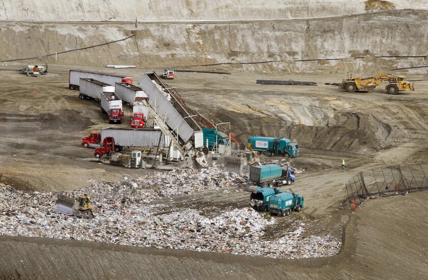
The Landfill Methane Problem
Municipal solid waste landfills are responsible for about 15 percent of human-caused methane emissions in the U.S. The Sunshine Canyon Landfill just north of Los Angeles is one of the largest in the country, receiving more than 8,000 tons of waste per day.
Public complaints about the odor emanating from the landfill had been ongoing for some time when Eugene Tseng, an engineer with expertise in solid waste facility management and design, was tasked with addressing them. Tseng, who is also a lawyer, describes himself as a “regulatory technical consultant” to the local enforcement agency.
Although methane has no smell, it is a carrier gas for odorous smells. “The most important thing in controlling odor is to control the landfill gas being generated,” he says. “The efficiency of the landfill gas collection system is paramount.”
Tseng used methane as a proxy for odor levels at the landfill and made his best estimate of the gas being generated. He set out to tackle the odor problem through extensive data mining and analysis that included operational data, the composition of waste delivered to Sunshine Canyon, the moisture content of trash, humidity and wind patterns. He designed and implemented solutions for what he had found.
NASA flyovers had previously determined that Sunshine Canyon was one of the major sources of methane emissions in the region, a “super emitter.” Though Tseng didn’t know it, NASA was continuing to monitor emissions from the landfill while he was implementing his mitigation efforts.
The most recent flyovers found that the amount of emissions was undetectable. Moreover, the reduction in emissions was equivalent to Tseng’s data on the increase in methane going into the landfill’s gas collection system and being destroyed through flares or converted to energy.
This independent data enabled Tseng to demonstrate to regulators that his efforts had succeeded. “This was really significant because many regulatory agencies have authority over the landfill and they don’t necessarily agree with each other on the correct mitigation measures.”
Subsequent flyovers have provided data that enables Sunshine Canyon operators to accomplish maintenance tasks such as identifying and repairing leaks around wellheads. “It turns out that if we have this real-time data, it can be used very beneficially by landfill operators and by regulatory agencies,” he says.
The red areas in this video represent methane plumes identified in a flyover of the Permian Basin in the southwest U.S., the country’s largest oil producing region.
Moving Toward Launch
Jeff Guido, the Carbon Mapper mission director at Planet, has spent his whole career in space operations, first in the Air Force and then at Google. The imaging technology that the project satellites will use, developed by JPL, has been operational for decades, he says. But this will be the first time that decision-makers who are not scientists will be able to leverage it.
“Our mission is to do good in the world,” he says. “This allows us to fill some significant data gaps with something that is substantive and actionable.”
The sensors in the Carbon Mapper satellite can detect much more than methane plumes, says Guido. “There are a lot of mechanisms, or activities, or processes that we can’t see in the visible wavelengths, but you can see in the shortwave infrared — things like plant stress, water quality, mineral detection. These are things that we believe will have application well beyond the methane use case.”
The methane data will be free to anyone who wants it, but Planet also hopes to develop resources that can be sold to companies or jurisdictions as tools to better manage natural and human resources. These could include applications for assessing environmental, social and governance risks and opportunities, an emerging use of satellite data.
“We like to think that we are building a system of systems,” says Guido. “There are numerous types of satellites that are partners to ours, that we are hoping to work with because they provide different strengths and different ways of seeing methane or whatever we want to look at.”

(Jessica Onsurez/TNS)
Making Methane Visible
The satellite imagery project highlights the importance of partnerships between the operators of systems that contribute to emissions and the agencies or nonprofits trying to address the climate crisis, says Deanna Haines. “By working together, we can help manage this issue much more efficiently and effectively.”
Greenhouse gas monitoring, and the technology that can take some of the guesswork out of climate change mitigation, are making their way across the “valley of death” between innovation and broad implementation.
“We’ve got to get across that chasm, and my prediction is that we’re on course to do that over the next three or four years,” Duren says. “When I say ‘we’ I mean a global community of people building these monitoring systems. It’s not just one crew.”