

Planning transit lines in video games like SimCity or Mini Metro is a cinch. You can easily see where there's demand for new service, whom it will serve and how much it will cost. If you mess up, it’s pretty easy to start over again.
Planning real-life transit routes, in contrast, has nothing like that point-and-click simplicity. In some cases, it can take weeks to figure out the consequences of moving a bus route over by just a few blocks.
But new software that can make designing and changing bus routes in reality more like it is in video games has arrived. It can make life a lot easier for transit planners and has the potential to make it easier for the public to weigh in on potential route changes. And if the new technology catches on with people outside the transit community, it could reshape how people see the relationship between transit and where they work and live.
The reason for such optimism is a web-based tool called Remix, which was first developed in 2014 as a project of Code for America, the nonprofit that promotes improved technology in the public sector.
Remix is now available through a subscription service. It lets users sketch out bus routes on a familiar interface much like Google Maps. It instantly provides users with information about costs and potential ridership. Remix also displays maps that show how far someone at any point on the map can go using transit within 15, 30 or 60 minutes.
“Remix is the first tool where we can really play with our ideas and see the outcomes instantly," said Jarrett Walker, a transit planning consultant who writes the Human Transit blog and who wrote a book of the same name. "We just move a lot faster. We have better ideas because we can think more or less continuously.”
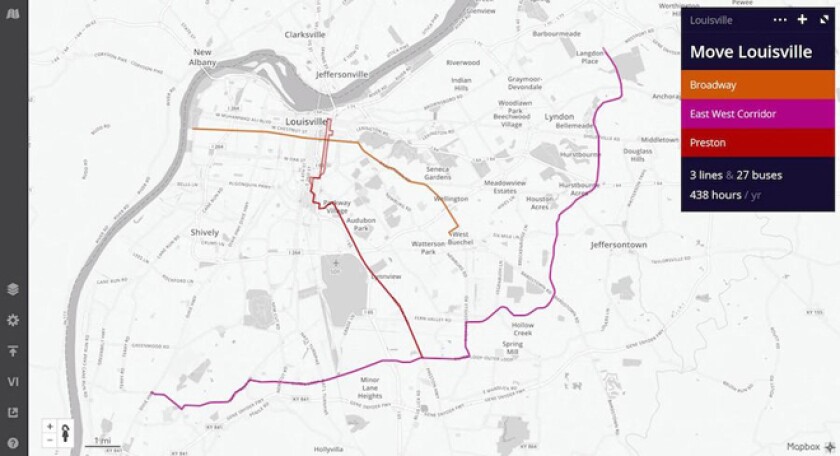
Louisville, Ky., used Remix to redesign three bus routes that traveled along the same corridor, so that they offered more service for longer hours with nearly the same cost. (Remix)
Until recently, there's been no simple interface for tracking costs, the neighborhood impact and a map of the routes all in the same place. Instead, planners have had to toggle back and forth between scheduling software, mapping software, graphic design software and spreadsheets as they develop proposals.
For local officials and the public, the set-up is so complicated it might as well be a black box. It makes it hard for the public to see why buses are overcrowded or empty, or why they never seem to come and why fares are going up.
One software package that's already used by most of the country’s top transit agencies plans to unveil tools similar to those offered by Remix in the late summer or early fall. Esri, a company that develops geographic information system, or GIS, software will release an update in the late summer or early fall version that will have a similar interface to Remix’s but will also incorporate lifestyle and economic data, according to Terry Bills, Esri's transportation industry manager.
Bills called Remix a “nice product” and said it would be particularly helpful for smaller transit agencies. But Esri focuses on mid- to large-sized agencies, which often want software that can keep track of how well their buses and trains are performing, coordinate with planning departments to determine how land-use patterns could affect ridership or even determine where to dispatch police to deter vandalism. Bills said those are kinds of analyses that Esri’s software can do, but Remix cannot.
Nevertheless, Remix already has many fans in the transit planning community.
Joshua Poe, a planner for the Transit Authority of River City in Louisville, Ky., has used Remix for several projects over the past year, including estimating costs for a proposed bus rapid transit route. He praised the software for being tailored for people in his profession.
"Transit planners have been lacking a long time in anyone building software with us in mind in terms of our daily needs," he said. "That's where Remix nailed it."
Poe said Remix helped him with a proposal to redesign three bus routes that traveled along the same corridor, so that they offered more service for longer hours with nearly the same cost. Because the information is presented in an easy-to-understand format, Poe could share information with management directly in Remix (although it can be exported in other formats, too). Poe also used Remix’s built-in demographic analysis tools to ensure that the changes would comply with federal anti-discrimination laws and regulations.
But Walker, the consultant and blogger, says Remix could be even more useful if it's made available directly to the public. It would appeal to people who have specific ideas for changes in the system, as well as to people who enjoy problem-solving.
“This borders on gamification,” he said. “Remix could really be turned into a game. It’s fundamentally about how to figure out how to sketch out a network that only costs so much but is useful to as many people as possible.”
Transit planners often hear from constituents who have very specific ideas about how bus routes should change, Walker noted. Right now, most transit agencies don’t have the capacity to evaluate those proposals. But if members of the public could experiment on their own, they could see why, for example, their idea would cost too much or attract too few riders.
Another feature that could help the public, said Walker, is Remix’s ability to generate area maps, called isochrones, of how far someone could travel via bus in a set amount of time. The images hit home with people who don’t otherwise think much about transit design, he said.
“These are the possibilities of your life,” he said. “This is where you can hold a job. These are the social opportunities you can go to. What the isochrones do is take the geeky facts about transit and turn them into something very visceral. The extent of those isochrones is, to some extent, the wall around your life.”
Bills, the executive from Esri, said increased transit use and the changing expectations of the public will drive even more changes in transit planning software.
“The younger generation is much more technologically savvy, so that’s putting greater pressure on these transit agencies to up their technology game,” he said. “We think that’s a good thing.”